


CREATE POINT CLOUDS FROM UAV RAW DATA
Transform and quailty control LiDAR and image data collected from your drone survey equipment.

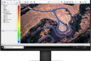
PROCESS, ANALYZE, & EXTRACT VALUE
Use an extensive toolbox of geospatial tools for deriving products that serve multiple industries and applications.

PUT YOUR DATA TO WORK
Deploy your accurate and fully processed data into actionable results or share with customers.


Before
After


Related products
-
-

Pix4Dcloud
Get an instant view of any jobsite from anywhere, on your browser, in 2D and 3D, with results you can measure, explore, compare, share and collaborate on.
-
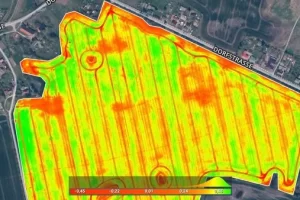
Pix4Dfields
Create accurate field maps, generate insights and analyze field data in real time to increase crop productivity