


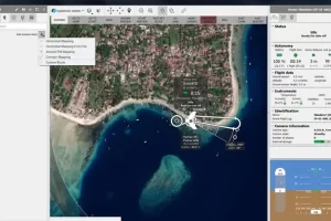
Accurate, fast drone mapping on a new scale
 Pix4Dmatic is designed to work with the latest generation of drones for professional applications and transforms your large number of images into accurate point clouds, DSMs and orthomosaics.


Related products
-
-
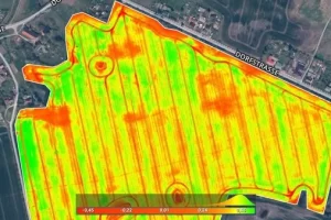
Pix4Dfields
Read moreCreate accurate field maps, generate insights and analyze field data in real time to increase crop productivity
-
LP 360 Geospatial
Read moreQuality control LiDAR data, extract information, and derive products from large datasets
-
Pix4Dmapper
Read moreDefine an area of interest, select processing options, add ground control points or edit point clouds, DSMs, meshes, and orthomosaics.