Trueview 535 – CartoCanada

Trueview 535

The TrueView 535 builds upon the success of our best-selling TrueView 515. We’ve added a third LiDAR beam return to improve vegetation capture detail, a third nadir camera to improve photogrammetry deliverables, and a longer usable LiDAR range to increase flexibility.

LiDar Scanner – Hesai M2X
LIDAR Beams/Returns – 32/2
Pulse Repetition Rate – 640 kHz
Triple Cameras – ‡120° cross-track FOV combined
Camera Sensor – Triple 1’’ mechanical shutter, hardware mid-exposure pulse, 60 MP combined, RGB

Categories ,

SHARE THIS PRODUCT ON:

TrueView 535 3D Imaging System

SpecificationValue
Data CollectionLIDAR + Imagery
Laser ScannerHesai M2X
LIDAR Range – Usable120 m @ 20% reflectivity
LIDAR Beams/Returns per Beam32/2
Cross-track Field of View (FOV)/Combined120°
Pulse Repetition Rate640 kHz
Network AccuracyTypical 3 cm*
PrecisionTypical 3 cm*
Camera SensorTriple 1’’ mechanical shutter, hardware mid-exposure pulse, 60 MP combined, RGB
Mass1.16 kg (payload unit only – no accessories including battery, mount, antenna, power adapter) 

Featured Applications

Before After
Before After
Before After

WHAT'S INCLUDED

HARDWARE

  • TrueView 535 3D LiDAR Payload 

ACCESSORIES/PARTS 

  • TrueView Battery + Battery Charger
  • USB Thumb drive
  • GNSS Antenna 
  • Sensor Hardcase 
  • Accuracy Star

SOFTWARE

SUPPORT

  • 1 year of hardware and software support
  • 2 days of free training at our Huntsville Headquarters

ADD-ONS

Looking for drone mapping equipment and accessories?  GeoCue sells mounting kits, batteries, drones, base stations and spare parts partnered with our bundled solutions. Contact our sales team to discuss all your equipment needs.

DRONES

MOUNTING KITS

BASE STATIONS

SPARE PARTS

INSURANCE

FINANCE

RENTAL AVAILABLE

Explore Drone LIDAR at Low Risk and Low Cost

The TrueView 535 3D Imaging System is available under our subscription offering!

This unique business model that allows customers to acquire a TrueView 3DIS under a subscription model for periods as short as 1 month! This is an excellent model for seasonal use and surge capacity.

Our TrueView Rental Program works off a point system giving users the ability to control the usage of their subscription hardware and processing workflow.

Integrations

TrueView Subscription TrueView 435 TrueView 515 TrueView 655/660
LP360 Drone  ✓
LP360 Desktop Photo Optional Add-On
LP360 Strip Align

LP360 Desktop Photo

We have built interfaces directly into our drone mapping processing software, LP360 Drone, for driving both an embedded version of Metashape (Metashape for LP360 Drone) as well as the full GUI version of Metashape Professional. This design provides a seamless photogrammetric workflow for users of LP360 Drone processing software. Metashape for LP360 supports the generation of:
  • LP360 Desktop Photo imagery for improving positional accuracy
  • Point clouds from imagery (“structure from motion”) – typically used in DJI camera workflows
  • Orthomosaics

LP360 Strip Align

Data can exhibit small geometric inconsistence, especially when combining data from multiple flights. BayesMap StripAlign for LP360 Drone detects and corrects these errors via an application of sensor-specific mathematical modeling. StripAlign is a fully automated process with no need for users to set project-specific “tuning” parameters or to move in and out of the LP360 Drone processing environment – press a button and it works! Image Exaggerated to Display StripAlign Effect 
Before After

DRONE PLATFORMS

Our TrueView 3D Imaging Sensors were designed as a lightweight payload to allow flexible integrations on numerous drone platforms. We have worked with several drone providers to provide customers the complete drone mapping solution they are looking for. Don’t see the company you’re looking for, contact our team and we can discuss custom intergrations!

True View 535 FAQ

Have questions about the TrueView 515 system? Review our TrueView 515 FAQ.

TrueView 3D imaging Sensors are designed and manufactured in our Huntsville, Alabama, USA facilities.

Data from a standard LIDAR system can be used to generate a 3D monochromatic point cloud.

Attributes of the point cloud typically include:

• X, Y, Z position in an exploitation spatial reference system (SRS)

• High resolution GPS time of pulse

• Intensity of the laser return

• Return number (if your LIDAR is multiple return capable)

• Scan angle (angle of the beam relative to nadir when this point was detected)

• Flight line (swath) ID


Note that no color (or, in general, radiometric) information is contained in the above information. A 3D imaging sensor (3DIS) includes both a laser scanner and one or more synchronized photogrammetric cameras (the TrueView 515 includes two Red-Green Blue photogrammetric cameras). The system is designed to achieve a coincident field of view (FOV) from all sensors. Post-processing software colorizes the points from the camera imagery to add, in the case of the TrueView 515, Red-Green-Blue (RGB) values for each LIDAR point. Note that the camera system in a 3DIS is not restricted to RGB cameras.

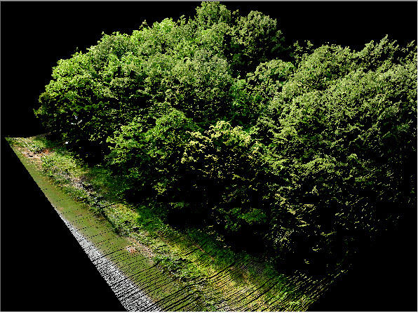
Derived products are what the name implies – analytic data derived from the base TrueView 515 products. These are generated using workflows and tools within LP360 Drone.

Examples of derived products include:

• Classified ground model – 3D LIDAR points that represent bare earth. These are generated using both automatic and manual editing tools in LP360 Drone

• Automatically derived planar surfaces such as building roof prints

• Topographic contours

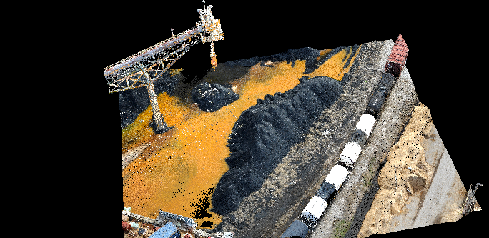
• Automatic and manual digitized stockpile boundaries (“toes”)

• Volumetric analysis such as stockpile volumes and cut/fill computations

• Profiles and cross sections

• Automatic rail extraction tools (classified rail points, vectorized center line)

• Automatic power line extraction tools (classified wire points, vectorized catenaries)

• Gridded elevation models derived from ground points and first surface points


In addition to the above, LP360 Drone supports feature-constrained (“breakline enforced”) modeling. This allows creation of surface data that is constrained by features such as water body boundaries, edge of pavement, downstream flow, retaining walls and so forth.